


Belair National Park GPS Chart app for iPhone and iPad
Developer: Flytomap
First release : 03 Feb 2011
App size: 20.66 Mb
Flytomap - "Solutions for better voyages"
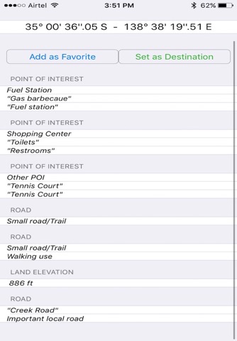
Belair National Park is the best place for leisure activities. The park today is home to a range of Australian flora and fauna including the South Australian blue gum and river red gum., there are tennis courts, picnic areas, free gas barbecues, a couple of sporting ovals and a kids adventure playground.
Belair National Park is a great place for recreation and for a trouble-free picnic under the sun.
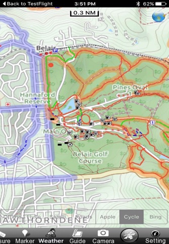
Belair Park map application is packed with extremely advanced embedded electronic charts with all information collected from the National Park Service and local sources. The maps contain all multiple trails (Hiking, biking, Stairway trails, Bicycle trails, Equestrian trails etc.,) and Point of interests (POI) like Campgrounds, Eating places, Ranger Stations, Picnic areas, Parking areas etc.,
About Map features:
Offline Park Map
Satellite Map Overlay
Topo Map Overlay
GPS to locate positions
Compass
Add unlimited Favorites
Record & email Tracks
Email favorites & Photos
Search places by name & Lat/Lon
Turn ON/OFF names and Elevation contours to avoid clutter
“Insert the target/destination ‘Waypoint’ and see in real time your speed, distance and direction to destination”
“Zoom, Rotate and Pan fast just by a finger touch”
“Geo-Tagged photo management”
................................& more
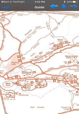
"Park Map contains Guide for quick reference with necessary links"
"Enjoy great voyages"
NOTE:
• Continued use of GPS running in the background can dramatically decrease battery life.
• Turn off GPS when not in use